Natural resources or natural resource potencies-
In a broad sense, it is that part of natural conditions and natural resources that can really be involved in economic activity with the given scientific, technical and socio-economic capabilities of society without disturbing the natural balance. In a narrower economic concept, it is a set of natural resources available under these technologies and socio-economic relations.
The leading place in the natural resource potential belongs to land, climate, water, forest, fuel and energy, mineral resources.
The land fund of Belarus as of 01.01.2002 is 20760.0 thousand hectares, of which about 45% are agricultural land (Table 3.1).
Table 3.1 Resource requirements by component
Dynamics of the structure of the land fund of Belarus,
[1, p.5; 2, p.61]
Types of land | Area, thousand hectares / % | ||
1990s | 1995 | 2002 | |
The entire land fund | 20759,6 | 20759,6 | 20760,0 |
100,0 | 100,0 | 100,0 | |
Including: | |||
agricultural land | 9346,3 | 9414,8 | 9204,7 |
45,0 | 45,4 | 44,4 | |
forests and other forested land | 8243,4 | 8229,2 | 8571,1 |
39,7 | 39,6 | 41,3 | |
Swamp | 958,5 | 948,8 | 934,0 |
4,6 | 4,6 | 4,5 | |
Underwater | 472,2 | 458,1 | 475,6 |
2,3 | 2,2 | 2,3 | |
under roads, clearings, purlins, pipelines | 344,8 | 326,9 | 358,4 |
17 | 1,6 | 1,7 | |
under streets, squares, courtyards and other common areas | 493,5 | 412,6 | 482,8 |
2,4 | 2,0 | 2,3 | |
other land, including disturbed | 900,9** | 969,2* | 733,4 |
4,3 | 4,6 | 3,5 |
* Excluding those used for peat mining and sapropel mining.
** Including former agricultural land contaminated with radionuclides.
The greatest agricultural development in the middle of the country is 50-54%, where the best soils, less waterlogging of land. About 93% of agricultural land is in public use. In their composition, the most productive are arable land, which accounts for about 65%. The share of arable land in the regions varies widely: the largest – in Mogilev (69.9%), Vitebsk (69.7%), Grodno (69.7%); the lowest – in Brest (58.1%), Gomel (61.7%) regions (Table 3.2). The share of arable land in the total land area is about 30.0%, the lowest in Gomel (22.4%), Brest (26%); the largest – in Mogilev (36%), Grodno (35.9%) regions. On average, there are about 0.6 hectares of arable land per inhabitant of Belarus, and in the Vitebsk region – 0.9 hectares, Mogilev – 0.8 hectares, Minsk – 0.4 hectares.
The share of hayfields and pastures in Belarus is 34.2% of all agricultural land. It is uneven across the districts. In the Belarusian Polesie it occupies 55.6%, in the middle zone, where a high percentage of arable land is 10-15%.
Table 3.2 Resource requirements by component
Distribution of agricultural land in Belarus by type
of land as of 01.01.2002, in %
Region | Arable Land | Pastures | Hayfields | Other Land |
Brest | 58,1 | 23,0 | 17,4 | 1,5 |
Vitebsk | 69,7 | 17,6 | 11,6 | 1,1 |
Gomel | 61,7 | 18,2 | 18,7 | 1,4 |
Grodno | 69,7 | 17,5 | 11,5 | 1,3 |
Minsk | 69,5 | 16,4 | 12,4 | 1,7 |
Mogilev | 69,9 | 17,0 | 12,1 | 1,0 |
Over the past 20 years, more than 70% of the area of hayfields and pastures has been improved by means of land reclamation (irrigation is carried out on 9 thousand hectares of hayfields and 62.9 thousand hectares of pastures). A big lack of pastures and hayfields is shallowness (the average size of the hay field is 4 hectares, pastures is 3.8 hectares), which is due to the complex rugged relief and heterogeneous soil cover.
The quality of agricultural land is quite low and is estimated in the republic at 34 points on a 100-point scale, arable land – at 36 points. There is a territorial differentiation: in the Grodno region, the bonite index of all agricultural land is 37 points, in the Brest and Gomel regions it is 33 points.
The productive power of the earth depends not only on the characteristics of the natural (natural) state, but also on the economic activity of people. 3.1.
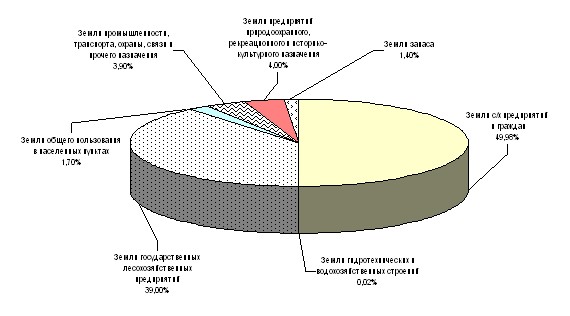
Rice. 3.1. Distribution of lands in Belarus by functional
usage as of 01.01.2002, [1, p.5]
Assessing the land resource potential of Belarus as quite high, it should be noted that changes in the structure of the land fund in recent years are associated with the processes of restoring the natural and economic potential of land, providing citizens with land plots, transferring low-productive agricultural land to forestry enterprises, optimizing agricultural land use. For these reasons, the area of agricultural land in 2000-2002 alone decreased by 101.4 thousand hectares As of January 1, 2003, the agricultural development of the lands of Belarus was 44.1%, and the ploughing – 27.3%, which indicates a fairly high degree of anthropogenic development of the country’s land fund. The area of mediastinizing land species (forest, natural meadow, under woody and shrubby vegetation, swamps and water) is 53.5% of the total land area and should be increased at the expense of low-productive lands, for example, Vitebsk region. Compared to the countries of Western Europe, Belarus is distinguished by greater preservation of forest and swamp areas. In addition, there is a higher availability of agricultural land per 1 inhabitant, including arable land (0.92 and 0.56 hectares, respectively), which is 1.5-2.0 times higher than in European countries. In the future, by increasing the culture of agricultural production, these indicators should be increased.
In large agricultural enterprises, favorable land accounts for 30.1%, good and satisfactory – 59.5%, unsatisfactory and bad with obviously unprofitable production – 10.4%. It is the latter that are intended for transformation into other types of farmland and use for non-agricultural purposes.
As a result of the disaster at the Chernobyl nuclear power plant, 1.3 million hectares of agricultural and 1.6 million hectares of forest land were exposed to radioactive contamination. As of January 1, 2003, 248.9 thousand hectares belonged to radiation-hazardous lands As a result of protective measures and a decrease in the mobility of cesium-137, its availability for plants for the post-accident period decreased by about 10-12 times, which led to the return of part of the contaminated land to agricultural circulation. By 2020, it is expected to reduce the area of radioactively contaminated land to 30 thousand km2 (15% of the total territory) against the current 43.5 thousand km2 (21%).
The effectiveness of land use largely depends on their erosion, rockiness and contouring, Table. 3.3.
Eroded land accounts for 9.4% of the total arable land area. In all regions, except Brest and Gomel, the share of eroded soils exceeds the average republican level. As a result of erosion, the yield reduction reaches 60%.
The most petrified lands are located in the northern, north-western and central regions of the country. Their area is generally close to the area of eroded land (9.9%), but they are located mainly in the Minsk and Vitebsk regions. Stonyness hinders the quality of land cultivation, increases the wear of equipment, reduces yields by up to 34%.
Table 3.3 Resource requirements by component
Characteristics of arable land of agricultural organizations of the Republic of Belarus in 2002 by erosion, stonyness and contouring in territorial aspect, [1, p.14]
Name Areas | Area of eroded land | Area of rocky lands | Average contour size, ha | ||
thousand hectares | % | thousand hectares | % | ||
Brest | 43,0 | 6,0 | 31,0 | 4,3 | 13,9 |
Vitebsk | 100,8 | 10,7 | 156,2 | 16,6 | 6,6 |
Gomel | 30,2 | 4,0 | 1,4 | 0,2 | 19,0 |
Grodno | 99,4 | 13,4 | 37,9 | 5,1 | 16,0 |
Minsk | 108,6 | 9,9 | 270,7 | 24,6 | 16,1 |
Mogilev | 97,5 | 11,2 | 9,1 | 1,0 | 18,2 |
Republic of Belarus | 479,5 | 9,4 | 506,3 | 9,9 | 12,2 |
The smallest size of the contour is observed in the Vitebsk region (6.0 hectares), which is two times less than the average for the republic. In other areas, the contour is above average. Shallow arable land is the reason for the reduced yield. So, on plots of 1-2 hectares, the yield can decrease by almost a third.
One of the serious problems of Belarus is the radioactive contamination of the land, Table. 3.4. As a result of the Chernobyl disaster, a fifth of the land was excluded from circulation. The farmland of the Gomel and Mogilev regions suffered the most.
Table 3.4 Resource requirements by component
Availability of radiation-hazardous lands of Belarus as of 1.01.2002, thousand hectares, [2, p. 65]
Land category | Altogether | Including | |
former agricultural land contaminated | forest lands and swamps | ||
Land owned and temporarily used by agricultural enterprises and farms | 50,6 | 47,1 | 3,5 |
Land Reserve | 11,0 | 10,9 | 0,1 |
Lands of forestry enterprises | 92,0 | 86,5 | 5,5 |
Lands of other land users | 95,3 | 92,4 | 2,9 |
Altogether | 248,9 | 236,9 | 12,0 |
Work is constantly being carried out in the republic to improve the condition of land: anti-erosion measures, reclamation, drainage. However, in general, the area of agricultural land, including arable land, is decreasing, Table. 3.5. In order to regulate land relations in 1999, the “Code of the Republic of Belarus on Land” was adopted. There are also positive changes in the dynamics of the structure of land use (an increase in the area of land for environmental and recreational purposes, etc.), which contributes to the environmentally sustainable development of the country.
Table 3.5 Resource requirements by component
Dynamics of the state of land in Belarus, thousand hectares, [2, p.66]
Types of land | Years | ||||
1975 | 1980 | 1990 | 1995 | 2000 | |
Agricultural land | 9892,9 | 9727,9 | 9414,8 | 9346,3 | 9281,5 |
including arable land | 6154,5 | 6211,3 | 5637,4 | 5972,9 | 5940,2 |
Drained lands | 2282,6 | 2716,7 | 3229,3 | 3373,4 | 3341,3 |
including agricultural | 1982,2 | 2241,6 | 2739,9 | 2885,6 | 2861,5 |
Reclaimed | – | 12,291 | 11,821 | 6,676 | 2,8 |